


Page 1 of 4
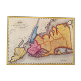
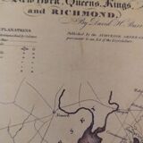
Historic map of New York in 1829
€17 €19
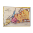
Historic map of New York in 1829
€17 €19
- Dimensions :
- H36 x W28 x D1
- Color :
- multicolour
- Material :
- paper
- Style :
- contemporary
Historic map of new york in 1829. Beautiful reproduction to frame. Map of the districts of new york, queens, kings and richmond based on a hand-coloured engraving by david h. Burr, an atlas of the state of new york, 1829. Dimensions: 27.7cmx35.4cm. Very good condition. I am available to answer your questions by message. - Careful packaging. - Free hand-delivery in paris (dugommier metro). - Shipments by colissimo or worldwide relay. International shipment, please contact me. - Don't hesitate if you have any questions or need a shipping quote.