


Item 1 of 10
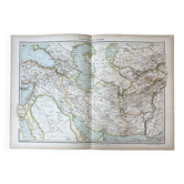
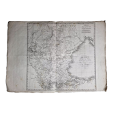
Old map of the Balkan Peninsula 69x54cm
€10

Old map of the Balkan Peninsula 69x54cm
€10
- Dimensions :
- H69 x W54 x D1
- Color :
- multicolour
- Material :
- paper
- Style :
- vintage
Map published by the Ch. Delagrave bookstore, Paris, no. 15. Coloured map of the Balkan Peninsula and Central Europe, detailed outline of borders, provinces, and reliefs, inset of the Bosphorus at a scale of 1:250,000. The presence of the Ottoman Empire, Austria-Hungary, and the Russian Empire places this edition in the last decades of the 19th century, a cartographic testament to a Europe that has now disappeared. Dimensions: 69 x 54 cm. Condition: some defects (tears, marked folds, and stains), reflected in the price. Careful and protected delivery, or free collection in Paris and Lyon.
Botanical & zoological posters: other similar vintage pieces
Discover more similar items- -31%
- -46%
- -57%




Item 1 of 20