Sold out


Item 1 of 7
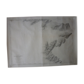
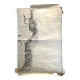
Map of the navy "cap corse - canelle - cap sagro" nº 4911
This item has found its owner, but other one-of-a-kind items await you. 👇
Discover similar items- Dimensions :
- H105 x W74
- Color :
- printed
- Material :
- paper
- Style :
- classic
PENINSULA OF CAP CORSE - NORTHERN PART - FROM POINTE DE CANELLE TO CAP SAGRO, Nº 4911. Map raised in 1890 and 1891. Map of the Hydrographic Service of the Navy "Mediterranean Sea Corsica". It is printed in 1:34800 scale on thick paper and has been used. Now it is stored rolled and remains despite some stains in good general condition. 105 X 74 cm. Other cards are on sale, do not hesitate to ask for a quote in case of multiple purchases for delivery costs.
Earth globes & geographical maps: other similar vintage pieces
Discover more similar items- -11%
- -30%
- Sold out
- -25%
- -24%
- -11%
- -20%
- -11%






Item 1 of 20