


Item 1 of 8
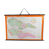
Vintage school map of czech state, czechoslovakia 1960s
€106€376

Vintage school map of czech state, czechoslovakia 1960s
€106€376
- Dimensions :
- H85 x W112 x D3
- Color :
- multicolour
- Material :
- paper
- Style :
- vintage
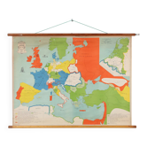
This is a great vintage school map of "czech state1526-1648". The map was produced by a national company skolske pomocky (school accessories) in 1960s in czechoslovakia. This map was originally used in schools to describe the origins and historical border of czech state, original czech republic to elementary school students. The map is made of paper on plastic with black wooden slats on bottom and top. Hangs on an original black twine. Very good condition with minor damages. Only minor age patina. Great wall decoration for any interiors.
Earth globes & geographical maps: other similar vintage pieces
Discover more similar items- -75%
- -25%
- -36%
- -26%
- -33%
- -30%
- -32%
- -29%





Item 1 of 20